| Regional Welcome Center | Maritime History theme destination | ||
| Level I sites | Coastal Habitats theme destination | ||
| Level II sites | Wildlife Migration theme destination | ||
| Points of Interest | New Jersey Watchable Wildlife Site |
"Those who contemplate the beauty of the earth find reserves of strength that will endure as long Rachel Carson
The Delsea Region is made up of Salem County, Cumberland County and part of Cape May County.. The region runs from the Delaware memorial Bridge in the west to the Garden State Parkway in the East.. That makes it about 48 miles from one end of the region to the other.
| Regional Welcome Center | Maritime History theme destination | ||
| Level I sites | Coastal Habitats theme destination | ||
| Level II sites | Wildlife Migration theme destination | ||
| Points of Interest | New Jersey Watchable Wildlife Site |
Other things to do in the region
Delsea Region Welcome Center
Fort Mott State Park
![]()
![]()
![]()
 Built for the federal government's post Civil War plan of defending Delaware River ports. Fort Mott was part of a three-fort
coastal defense system which also included Fort Delaware on Pea
Patch Island and Fort DuPont in Delaware City,
Delaware. A ferry connecting the three forts
operates seasonally. Ten and twelve inch guns
were mounted on disappearing carriages with
an effective range of eight to ten miles,
sufficient to match or cut-range the guns of
contemporary naval vessels. Welcome Center exhibits on the
maritime history theme and Trail information are available.
Built for the federal government's post Civil War plan of defending Delaware River ports. Fort Mott was part of a three-fort
coastal defense system which also included Fort Delaware on Pea
Patch Island and Fort DuPont in Delaware City,
Delaware. A ferry connecting the three forts
operates seasonally. Ten and twelve inch guns
were mounted on disappearing carriages with
an effective range of eight to ten miles,
sufficient to match or cut-range the guns of
contemporary naval vessels. Welcome Center exhibits on the
maritime history theme and Trail information are available.
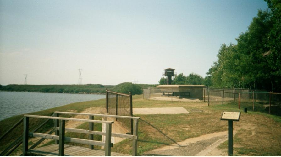 On your way dawn if you look of to your left you will see a big black tower.
This is the Finns Point Rear Range Lighthouse. Just before the entrance to the
park is the entrance to the Finn's Point National Cemetery. Be sure to go early
because there is lots to do and see. There is a picnic area and a playground for
the kids.
On your way dawn if you look of to your left you will see a big black tower.
This is the Finns Point Rear Range Lighthouse. Just before the entrance to the
park is the entrance to the Finn's Point National Cemetery. Be sure to go early
because there is lots to do and see. There is a picnic area and a playground for
the kids.
Directions: Heading east on state road 49, take county road
630 (Fort Mott Road); heading west on SR49, take CR632
(Lighthouse Road), and follow the Fort Mott State Park signs.
Hours: The grounds of the fort are open daily from 8:00am to
7:30. Open from Memorial Day to Labor Day, and 8:00am to
4:00pm for the remainder of the year.
Telephone: (856) 935-3218
More information: You can find more information on Fort Mott you can
check out the History of Fort Mott, activities at Fort Mott and a news
paper article written about Fort Mott or check out the Walking Tour of Fort Mott. You can also see what
is happening on the Calendar of Events.
Finn's Point National Cemetery
![]()
![]()
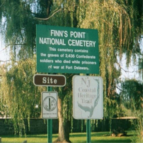 The cemetery is the resting place for 2,436 Confederate soldiers
whose military careers ended as prisoners of war under the
custody of the Federal Union. These men were interned near here
at Fort Delaware on Pea Patch Island. Many had been captured
during the Battle of Gettysburg, July 1863. Union soldiers who
died while serving as guards at the prison camp are also buried
here. Interpretive exhibits explain the cemetery's history.
The cemetery is the resting place for 2,436 Confederate soldiers
whose military careers ended as prisoners of war under the
custody of the Federal Union. These men were interned near here
at Fort Delaware on Pea Patch Island. Many had been captured
during the Battle of Gettysburg, July 1863. Union soldiers who
died while serving as guards at the prison camp are also buried
here. Interpretive exhibits explain the cemetery's history.
Check out the names on the monuments of the soldiers that are buried there. You just might find that one of these soldiers was an ancestor of yours. The Confederate soldiers were placed on one side of the cemetery while the Union soldiers were placed on the other side.
Directions: Follow directions to Fort Mott State Park. Just
before the main entrance to the state park, turn right and
follow the signs for the cemetery.
Hours: Open daily from 8:00am to 5:00pm.
Telephone: (609) 877-5460
Finns Point Rear Range Light
![]()
![]()
![]() The Finns Point Front and Rear Range Lights served as a
navigational point for maritime traffic moving between the
Delaware Bay and River in 1950 after the Army Corps of
Engineers dredged the river -- channel the Finns Point range
lights became obsolete. the U. S. fish and Wildlife Service
and a local citizen's group restored the tower in 1983.
Interpretive exhibits demonstrate how range lights were used
by mariners navigating the river channel. The light house sits on the edge of
Supawna Meadows National Wildlife Refuge, which is over 2000acres of protected
meadowland.
The Finns Point Front and Rear Range Lights served as a
navigational point for maritime traffic moving between the
Delaware Bay and River in 1950 after the Army Corps of
Engineers dredged the river -- channel the Finns Point range
lights became obsolete. the U. S. fish and Wildlife Service
and a local citizen's group restored the tower in 1983.
Interpretive exhibits demonstrate how range lights were used
by mariners navigating the river channel. The light house sits on the edge of
Supawna Meadows National Wildlife Refuge, which is over 2000acres of protected
meadowland.
Directions: Follow directions to Fort Mott State Park. It is
located at the intersection of county roads 630 & 632.
Hours: Interpretive exhibits are accessible during daylight
hours. The lighthouse is open from noon to 4:00pm on the
third Sunday of each month from April through October.
Group requests accepted.
Telephone: (856)935-1487
More information: To find out the dates the Light house is open look at the Calendar of Events.
Alloway Creek Watershed Wetland
Restoration Site
![]()
![]()
![]()
This site consists of 2,840 acres of wetlands and 130 acres of
upland adjacent to Alloway Creek and the Delaware River
restored by PSE&G to provide more fish habitat. Restoration
efforts here have focused on reducing the invasive weed, Phragmites. Observation platforms, a nature trail, and a bird
viewing blind provide opportunities to see migratory and
resident birds, as well as other wildlife that inhabit the area.
Directions: There are multiple access areas. From state road
49 in Salem, travel southwest for two miles on CR658, which
initially is named York St, and changes into Salem-Hancock's
Bridge Rd. Turn right onto Ft. Elfsborg Rd., left on Money
Island Rd., and follow it to the end.
2) From SR49 in Salem to
Chestnut St. (CR 625) west. The road name changes to Ft. Elfsborg-Salem Rd, and parking is at the end of the road.
3)
There is also viewing adjacent to the Hancock House.
Hours: Open daily from dawn to dusk.
Telephone: 1-888-MARSHES (888-627-7437).
Hancock House State Historic Site
![]()
![]()
 Built in 1734 by Judge William Hancock, the house is the site
of a massacre that took place during the American Revolution
on the morning of March 21, 1778. A British force of nearly
300 men surprised and bayoneted a small band of 30 colonial
militiamen who were sleeping there. The house is a fine
example of "pattern brick architecture" with the initials of
William and Sarah Hancock, the year of construction, and a
herringbone pattern displayed on the west wall of the house.
Built in 1734 by Judge William Hancock, the house is the site
of a massacre that took place during the American Revolution
on the morning of March 21, 1778. A British force of nearly
300 men surprised and bayoneted a small band of 30 colonial
militiamen who were sleeping there. The house is a fine
example of "pattern brick architecture" with the initials of
William and Sarah Hancock, the year of construction, and a
herringbone pattern displayed on the west wall of the house.
Directions: From state road 49 in Salem, follow county road
658 south to Hancock's Bridge.
Hours: The house interior is open 10:00am to 4:00pm daily
from Memorial Day to Labor Day, each first and third
Saturday in the off-season, and by appointment. The grounds
are open from dawn to dusk.
Telephone: (856) 935-3218 (Fort Mott).
More information: The story of the Hancock
House makes for very interesting reading. There is also the story of what happened in 1777
and the History of Salem. You can find out what is happening on the Calendar of Events.
Stow Creek Viewing Area
![]()
![]()
![]()
This New Jersey Fish, Game and Wildlife site features a bald
eagle nest and provides an opportunity for visitors to learn
about the state's eagle restoration efforts. An access road,
parking area, elevated boardwalk, interpretive exhibits, and a
viewing platform provide a way to enjoy the eagles, the salt
marsh, and its wildlife species.
Directions: From state road 49 in Salem, turn south on county
road 658 (Hancock's Bridge Rd.). At Hancock's Bridge,
CR658 makes a left at the traffic light. Turn south (right) at the
next light onto CR623 (New Bridge Rd.) toward Canton,
travel about 8 miles to the parking area on the south (right)
side of the road, just before the bridge over Stow Creek.
Hours: This unstaffed area is open daily from dawn to dusk.
Telephone: NJ Div of Fish & Wildlife (609) 628-2103.
Greenwich Tea Burning Monument (Historic Greenwich
Village)
![]()
![]()
Cumberland County was a hotbed of patriotic fervor in the
months and weeks prior to the first shot which began the
American Revolutionary War. In the town square of Greenwich on December 22, 1774, young men dressed as Indians
broke open a supply of East India tea, bound for consignment
at the port of Philadelphia, and burned it in protest of the
heavy British taxes levied on the American colonists. The
Cumberland County Historical Society erected a monument on
the site in commemoration of the event in 1908.
Greenwich is a village rich in Revolutionary War history. Many of the buildings in Greenwich dating from the colonial period are still standing in this village that was the site of New Jersey's Tea Party. Enjoy visiting museums located along Ye Greate Street (call for hours of operation)
Directions: From state road 49 westbound, take CR607 south
at Bridgeton. Eastbound on SR49, take CR620 south at Shiloh,
then left onto CR623 (Ye Create Street) in Greenwich.
Hours: Accessible daylight hours only.
Telephone: Cumberland Co. Historical Soc. (856) 455-4055.
Green Swamp Nature Area
![]()
![]()
The Green Swamp Nature Area is part of a 930-acre wetland
restoration site along the Cohansey River. Public Service
Electric and Gas Company (PSE&G) purchased the property
in 1994 to increase fish productivity. Restoration efforts here
have focused on reducing the invasive weed, Phragmites. A
short hiking trail transects an open field, woodland, salt marsh,
and freshwater wetland. Enjoy a variety of wildlife, from
nesting osprey to feeding butterflies. A public boat ramp
provides access to the water,
Directions: Follow county route 553 into Fairton and turn
south on Back Neck Road. Follow it approximately two miles,
and the parking area is on the right.
Hours: This unstaffed area is open daily from dawn to dusk.
Telephone: 1-888-MARSHES (888-627-7437).
Peek Preserve
![]()
![]()
The Harold N. Peek Preserve, owned by Natural Lands Trust,
is located along the freshwater, tidal portion of the Maurice
River. The hiking trails will lead you through many different
habitats, including wild rice marsh, Atlantic white cedar,
hardwood swamp, chestnut oak upland, pine barrens, and a
Virginia pine succession field. Waterfowl, bald eagles, osprey,
turkeys, and great homed owls are just a few of the birds that
utilize the natural resources of the preserve.
Directions: From Millville, follow state road 47 south 1,5
miles. Parking is on the right, across from Lilac Avenue. From
the south, follow SR 47 north and take the jug-handle at the
base of SR 55 to stay on 47. Continue north 3.5 miles, and the
entrance is on the left.
Hours: This unstaffed area is open daily from dawn to dusk.
Telephone: (856) 447-3425.
Manumuskin River Preserve
![]()
![]()
![]()
The Nature Conservancy's Manumuskin River Preserve, at
over 3500 acres, is comprised of a variety of habitats including
mudflats, upland forest, grassy meadows, wild rice stands, and
lowland swamps. In addition to 30 other rare species, the
world's largest population of the globally rare sensitive joint-
vetch is protected on the preserve. The tidal wetlands here
have never been diked and thus have great plant diversity.
Remains of the 1790s settlement of Fries Mill are also part of
the preserve. To hike the nature trail, begin at the trailhead
located at the preserve entrance off Schooner Landing Road.
One of the world's largest concentrations of endangered plants and animals is located on the 3.6 miles of Manumuskin river front. the Manumuskin supports New Jersey's best freshwater tidal marsh systems and is home to the rare pine snake and the dotted skipper butterfly.
Directions: Take state road 55 south to exit 21/Schooner
Landing Rd. Turn left at the stop sign. Follow the road to the
gate at the end. The Preserve trail is to the right of the gate.
Hours: This unstaffed area is open daily from dawn to dusk.
Telephone: (609) 861-0600.
Peaslee Wildlife Management Area
![]()
![]()
![]()
![]()
One of the largest wildlife management areas in the state,
Peaslee has thousands of acres of upland pine-oak forests and
lowland bogs. Its longest border is the upper part of the
Tuckahoe River. Old cranberry bogs and a mill are in the early
stages of succession, and offer excellent freshwater marsh
habitats. Discover the diverse habitats the wooded edge-pinelands, cedar bog, hardwood swamp, scrub oak forests,
sweet ferns, grassy fields, and yellow-clover pasture.
Directions: From state road 55 exit 24, take SR49 east to
county road 644 (Hesstown Road), about 5 miles. Turn left,
and proceed 1.7 miles. Turn east (left) on the sand road for a
1.6 mile auto tour loop.
Hours: This unstaffed area is open daily from dawn to dusk.
Telephone: NJ Div. of Fish & Wildlife (856) 629-0090.
Glades Wildlife Refuge
![]()
![]()
![]()
 Located along the Delaware Bay, this area
is a conservation project of the Natural
Lands Trust, a regional land trust based in
Media, Pennsylvania. In addition to the salt
marsh and hardwood swamp forest, you may
find tidal marsh with interlacing creeks and
ponds, farm fields, mixed woodlands, old-growth woodlands, and beach habitats. Russell Farm Trail is
one of several opportunities to explore the area
Located along the Delaware Bay, this area
is a conservation project of the Natural
Lands Trust, a regional land trust based in
Media, Pennsylvania. In addition to the salt
marsh and hardwood swamp forest, you may
find tidal marsh with interlacing creeks and
ponds, farm fields, mixed woodlands, old-growth woodlands, and beach habitats. Russell Farm Trail is
one of several opportunities to explore the area
Directions: From county road 553 at Newport, turn south onto
CR656 and then south on CR637 at the blinking yellow light.
Follow the signs to Fortescue. Parking for the Russell Farm
Trail is located 2.4 miles south from the Newport blinker (on
the left.) For access to the dunes and beach, continue into
Fortescue and turn left onto New Jersey Ave. Follow that until
the sea wall along the road ends.
Hours: This unstaffed area is open daily from dawn to dusk.
Telephone: (856) 447-3425.
Fortescue State Marina
![]()
![]()
Fortescue is known as the "Weakfish Capital of the World."
The marina was purchased by the State of New Jersey in the
late 1930s to aid in the enforcement of shellfish fisheries
management in the Delaware Bay. Today, the marina is
operated by the Fortescue Captains and Boat Owners Association. The majority of the slips contain charter vessels (both
large and small).
Directions: The marina can be reached via county roads 553
and 656 to Newport and continuing south on CR637 to
Fortescue.
Hours: An interpretive exhibit on the history of New Jersey
marinas is accessible during daylight hours.
Telephone: (856) 447-5115.
Egg Island Wildlife Management
Area (Turkey Point)
![]()
![]()
![]()
![]()
The vast, windswept salt marsh here is dotted with hummocks
of cedar trees, bayberry bushes, sumac, and common reeds.
Numerous tidal creeks await the explorer, crabber, and angler.
There is a large pond in the middle of the tract, which
wintering waterfowl find attractive. A foot bridge and observation platform are planned to connect the parking area and
walking trails in the marsh. Watch for marsh wrens, seaside
sparrows, northern harriers, gulls, egrets, and herons. In
midsummer, be prepared for biting deer flies and green-head
flies.
Directions: From county road 553 in Dividing Creek, turn
south onto Maple Street. Take Maple St. 2.7 miles to the road
end and the footbridge into the wildlife management area.
Hours: This unstaffed area is open daily from dawn to dusk.
Telephone; NJ Div. of Fish & Wildlife (856) 629-0090.
Commercial Township Wetland
Restoration Site
![]()
![]()
Portions of this 4200 acre site were diked as early as the
eighteenth century to limit tidal flow from the Delaware Bay
for salt hay farming. Public Service Electric and Gas Company (PSE&G) purchased the property in 1994 and created a series
of channels and inlets throughout 3000 acres in 1997 to restore
normal tidal flow and the native marsh vegetation. The site
now provides important spawning, nursery, foraging, and
refuge habitat for fish and other wildlife of the estuary. Two
elevated boardwalks and a two-mile (one way) nature trail
link the three access and viewing platforms.
Directions: There are three access points to the public use
facilities: just off CR553 at the end of Strawberry Avenue on
the north edge of Port Norris, off Germantown Avenue, and at
the end of High Street near Bivalve.
Hours: This unstaffed area is open daily from dawn to dusk.
Telephone: 1-888-MARSHES (888-627-7437).
Delaware Bay Schooner Project
![]()
![]()
The Schooner Project, founded in 1988, educates the citizens
of the Delaware Estuary about the region's natural resources
and maritime culture. The Project owns and operates New
Jersey's official Tall Ship, the 1928 Delaware Bay oyster
schooner A. J. Meerwald. Its home port is the historic oyster
shipping sheds on the Maurice River in Bivalve,
which offer a window to the Delaware Bay's
past and current oyster industry. The
schooner travels from port to port
providing educational sails and special
on-board programs for school children and the
public. The Project also maintains the Delaware Bay Museum
in Port Norris with exhibits highlighting maritime traditions of
the Delaware Bay.
Directions: From county road 553 turn south on High St. in
Port Norris and follow the signs to the schooner, docked
behind the Project office at 2800 High Street. The museum is
located at 1727 Main Street, Port Norris.
Hours: The Schooner wharf is open year-round; call ahead for
sail schedule. The museum is open April through October from
1:00pm to 4:30 pm on Saturday and Sunday.
Telephone: (856) 785-2060 or 1-800-485-3072.
Heislerville Wildlife Management Area
![]()
![]()
![]()
A driving route winds through the tidal marsh boundary,
brackish impoundments, salt-hay meadows, tidal mud flats,
and oak-pine uplands. The Maurice River flows past the area
to the Delaware Bay. Bird-watchers enjoy wintering snow
geese and the occasional bald eagle. Mute swans live here
year-round. Horseshoe crabs spawn on the beaches during
May, attracting thousands of migratory shorebirds.
Directions: Turn west at the traffic light for the Mauricetown
turnoff from state road 347 and south (left) at the next light
following SR47 south. In approximately another 3 miles, turn
west (right) onto CR740 (Mackey's Lane). Proceed 0.3 miles
to CR616 (Dorchester-Heislerville Rd.), and turn left. Travel
2.2 miles to CR736 (Matts Landing Road). Turn right, proceed
1 mile past the impoundments, and parking is on the left.
Hours: This unstaffed area is open daily from dawn to dusk.
Telephone: NJ Div. of Fish & Wildlife (856) 629-0090.
East Point Lighthouse
![]()
![]()
Constructed in 1849, this "Cape Cod" style lighthouse
provided Delaware Bay oyster schooners with a navigational
marker to the ports of Port Norris, Millville, Mauricetown, and
Port Elizabeth. It is the second oldest lighthouse still standing
in New Jersey. Observe the annual migration of thousands of
shorebirds in late May, when the horseshoe crabs come ashore
to lay eggs. In early fall, watch for the annual migration of
monarch butterflies.
Directions: Take county road 616 (Glade Rd.) west from state
road 47 to Heislerville, and continue west on East Point Road.
Hours: The lighthouse is undergoing restoration, and the
building interior is not open to the public except for special
events. There is an annual "open house" on the first Saturday
of August.
Telephone: (856) 327-5700 or (856) 327-3714
Maurice River Township Wetland Restoration Site
![]()
![]()
![]() This 1390 acre site was previously diked to exclude tidal flow
from the Delaware Bay for salt hay farming. In
1994, Public Service Electric & Gas
Company (PSE&G) purchased the
property. In 1997, a network of channels and
inlets was created through 1000 acres to restore the habitat
that is important to the reproduction cycles offish. The site
now provides important fish and wildlife habitat. Two boat
ramps and an observation platform make this an excellent site
for fishing, crabbing, and bird watching.
This 1390 acre site was previously diked to exclude tidal flow
from the Delaware Bay for salt hay farming. In
1994, Public Service Electric & Gas
Company (PSE&G) purchased the
property. In 1997, a network of channels and
inlets was created through 1000 acres to restore the habitat
that is important to the reproduction cycles offish. The site
now provides important fish and wildlife habitat. Two boat
ramps and an observation platform make this an excellent site
for fishing, crabbing, and bird watching.
Directions: Traveling south on state road 47 from Dorchester
and Leesburg, turn west (right) on CR616 (Glade Rd) toward
Heislerville. After approximately 1.5 miles, turn left onto
Thompsons Beach Road and continue to the restoration site
parking area.
Hours: This unstaffed area is open daily from dawn to dusk.
Telephone: 1-888-MARSHES (888-627-7437).
Belleplain State Forest
![]()
![]()
![]()
Belleplain State Forest was established in 1928 for recreation,
timber production, wildlife management, and conservation of
water supplies, The forest stand includes pine, oak, and
Atlantic white cedar. Demonstrations of reforestation are
conducted to study the production of forest related crops and
the conservation of forest resources. Recreational activities
include picnicking, boating, camping, hunting and fishing,
swimming, and hiking over 40 miles of trails. The staff also
conducts seasonal interpretive programs.
Directions: From state roads 47 or 347, turn east on county
road 550 through the community of Belleplain. The main
entrance is halfway between the communities of Belleplain
and Woodbine. From the Garden State Parkway, take exit 17
and follow US9 north to the intersection with CR550. Follow
CR550 and the Forest signs west through Woodbine.
Hours: The area is open from dawn to dusk. The lake is open
for swimming from 10:00am to 6:00pm from Memorial Day to
Labor Day.
Fees: A recreation use fee is charged for camping and picnicking.
Telephone: (609) 861-2404.
Eldora Nature Preserve
![]()
![]()
![]()
The home of renowned entomologist Dr. C. Brooke Worth is
now located on The Nature Conservancy's Eldora Nature
Preserve Here, you will also find the Conservancy's Delaware
Bayshores Office, interpretive exhibits, several aquariums, a
display of local moths and butterflies, a gift shop, butterfly
garden, and a hummingbird garden. A nature trail leads
through woodlands on the way to the marsh.
The Eldora Nature Preserve is the first preserve established by
The Nature Conservancy in New Jersey for the conservation of
insects, particularly moths and butterflies. A fenced area
protects the red chokeberry, a host plant for rare moths.
Songbirds and hawks are often seen among the adjacent fields
and forest
Directions: From Cumberland County, take state road 47
south into Cape May County. The Preserve entrance is the first
building on the left after entering Cape May County.
Hours: Open daily from dawn to dusk.
Telephone: (609) 861-0600.
Dennis Township Wetland Restoration Site
![]()
![]()
 This 560 acre site was diked in the 1950s to exclude tidal flow
from the Delaware Bay for salt hay farming. Public Service
Electric & Gas Company (PSE&G) purchased the property in
1994 as part of a program to help increase fish productivity.
PSE&G modified 365 acres of the site in
1996 by creating a network of channels
and inlets to restore normal tidal flow
and the growth of desirable marsh
plants. The site now provides important habitat for fish
and other aquatic organisms. Bring your binoculars and
explore the salt marsh via the nature trail. A floating observation platform allows you to experience a mudflat at low tide
and the center of a tidal creek at high tide.
This 560 acre site was diked in the 1950s to exclude tidal flow
from the Delaware Bay for salt hay farming. Public Service
Electric & Gas Company (PSE&G) purchased the property in
1994 as part of a program to help increase fish productivity.
PSE&G modified 365 acres of the site in
1996 by creating a network of channels
and inlets to restore normal tidal flow
and the growth of desirable marsh
plants. The site now provides important habitat for fish
and other aquatic organisms. Bring your binoculars and
explore the salt marsh via the nature trail. A floating observation platform allows you to experience a mudflat at low tide
and the center of a tidal creek at high tide.
Directions: Follow state road 47 north from Dennisville. Turn
west (left) at the traffic light with the intersection of SR347,
and follow it approximately 2.2 miles to Eldora. Turn south
(left) onto Stipson's Island Road, and follow it to the end.
Hours: This unstaffed area is open daily from dawn to dusk.
Telephone: 1-888-MARSHES (888-627-7437).
Dennis Creek Wildlife Management
Area (Jake's Landing)
![]()
![]()
![]()
![]()
The vast expanse of marsh grass is a striking view. Several
tidal creeks and drainage canals traverse this area providing
channels for marine fish to spawn. The northern harrier can be
seen silently gliding low over the marshes in search of food
for its young. Often the egrets and herons shuffle through the
musty waters in search of food. Muskrats busily gather marsh
grasses and reeds to construct their domed lodges where they
may seek refuge from the weather and predators. Dennis Creek
has an observation platform and a boat launch for small craft
and canoes to explore the marshes.
Directions: Follow state roads 55 & 47 south from Millville to
the community of North Dennis. Watch for the intersection of
CR557. Travel 0.3 miles further south on SR47 to Jake's
Landing Road. Turn west (right) on Jake's Landing Road, and
follow it to the end - approximately 1.5 miles to the parking
lot, boat ramp, and Dennis Creek.
Hours: This unstaffed area is open daily from dawn to dusk.
Telephone: NJ Div of Fish &Wildlife (856) 629-0090.
Cape May Bird Observatory
![]()
![]()
![]()
![]()
Administered by the New Jersey Audubon Society, the Cape
May Bird Observatory is dedicated to perpetuating and
preserving the ornithological significance and natural history
of the Cape May area. CMBO offers year-round bird and
butterfly watching walks, programs, and workshops. CMBO's
Center for Research and Education in Goshen has a classroom,
full nature bookstore, wildlife art gallery, extensive natural
history information, trails, and bird feeding station. A "Model
Backyard Habitat" serves as an outdoor classroom for visitors
interested in learning how to attract and garden for wildlife,
including butterflies and hummingbirds.
Directions: Follow state road 47 south from Dennisville. The
center is located on the east side ofSR47, just south of the
intersection at CR657.
Hours: The center is open daily from 10:00am to 5:00pm.
Telephone: (609) 861-0700.
Cape May National Wildlife Refuge
![]()
![]()
![]()
 Established in January of 1989, Cape May National Wildlife
Refuge is one of the newest refuges in the National Wildlife
Refuge System. The refuge provides critical habitat for
migratory birds and wildlife. It supports 317
bird species, 55 reptile and amphibian species,
42 mammals, and numerous fish, shellfish,
and invertebrates. The refuge has upland and
lowland forests, fields, sandy beach, salt
marshes, tidal creeks, and ponds. Several foot trails
provide excellent opportunities for birding, nature photography, and environmental education.
Established in January of 1989, Cape May National Wildlife
Refuge is one of the newest refuges in the National Wildlife
Refuge System. The refuge provides critical habitat for
migratory birds and wildlife. It supports 317
bird species, 55 reptile and amphibian species,
42 mammals, and numerous fish, shellfish,
and invertebrates. The refuge has upland and
lowland forests, fields, sandy beach, salt
marshes, tidal creeks, and ponds. Several foot trails
provide excellent opportunities for birding, nature photography, and environmental education.
Directions: Go west from exit 10 of the Garden State Parkway
at Cape May Courthouse, then turn south on US9. Turn west
(right) on county road 658 (Hand Avenue.) Turn south on
SR47, then immediately west onto Kimbles Beach Rd. The
entrance to the office is on the right.
Hours: The office is open weekdays from 8:00am to 4:00pm.
The refuge is open daily from dawn to dusk.
Telephone: (609) 463-0994.
 Copyright © 2001-
, Terry Muse
Copyright © 2001-
, Terry Muse
![]()