New Jersey's maritime heritage is rooted in the interdependent stories of trade, navigation, and coastal defenses.
The resources of the ocean, bays, adjacent rivers, and tributaries supported the fishing trades, which in turn sustained boat building and related industries. Navigable waterways and protected harbors encouraged intercity commerce. Lighthouses were built to warn mariners of hazards to their ships and prevent loss of crew and cargo. Defense of port cities ensured that maritime trade would continue.
INDUSTRY AND TRADE
The Barnegat
Bay Sneakbox, a small, shallow draft, broad-beamed sailing boat, was designed in the 1830s
to be easily poled into the reeds and camouflaged. Originally used as a duck blind, the
design was so popular that it was adapted and
produced in a variety of sizes for different uses.
Examples of the Sneakbox and other boats
native to the New Jersey coast can be found at
the Toms River Seaport Society Museum.
Because of the relative abundance of lumber,
boat and shipbuilding became major industries
during the 19th century. Today, fishing-both
commercial and sport-is the basis of the
region's economy.
Fishing and boat building have been associated with the New Jersey coast since the days of the
Lenape Indians. From Manasquan north to Sandy Hook and along the Raritan Bay to
Perth Amboy, fishermen, clammers and oystermen thrived on the ocean's bounty.
The Bayshore's modern fishing industry survives with Belford's Seafood CO-OP.
Other commercial fishing fleets, such as Leonardo's have dissolved and the docks
have evolved into recreational marinas. By the 1900s, boat building and other maritime
industries were supported by the thriving oyster trade on the Delaware Bay. Shad, sturgeon, and
crab fishing complemented the shellfish industry.
Cargo and trade ships carried New Jersey agricultural goods to ports up and down both seacoasts.
Today, remnants of 19th and early 20th century maritime economies can be found in fishing
vessels working the Bay and in small industries found along tidal rivers. Modern
examples of traditional trades such as boat building still survive. Towns with evocative names like
Bivalve and Shellpile support maritime industries, carrying the past into the present.
Tradition holds that on the island of Brigantine the Lenape Indians used the abundant clam shells to
make wampum. Later, during the 17th century, Cape May's prosperous whaling industry
encouraged pioneering settlers to build year-round communities. Although over
hunting of cow whales ended this profitable venture by the mid-eighteenth century,
the communities remained.
By the late eighteenth century, these coastal settlements began to rely on other forms of
commercial enterprise: fishing, farming, cattle, and shipbuilding. As far inland as Mays Landing
and Tuckahoe, boats were built along tidal streams and floated down to the bay and ocean.
New Jersey's plentiful supply of good lumber supported this fast growing industry.
The population of the Absecon and Cape May regions boomed in the 1850s with the building of
railroads and the development of resort towns, such as Atlantic City.
Sailboats and steamships, built in Keyport through the end of the nineteenth century, are
remembered at Keyport's Steamboat Dock Museum. Trains and steamboats were a common sight
along the shore, bringing visitors to summer homes and playgrounds. Fishing villages had become
"resorts," and "tourism" was the new industry.
AIDS TO NAVIGATION
The Intercoastal
Waterway, a series of protected passages hugging the shoreline, allows small ships to travel
the east coast without being subjected to the
perils of the open sea. The north entrance is
located in Manasquan Inlet near Point Pleasant.
It follows the Atlantic shoreline in protected
back bays, south to Cape May and into the
Delaware River.
Coastal trading and shipping routes were often hazardous, especially during winter storms.
Lighthouses were constructed as early as the 1700s to warn ships of potential dangers. The Sandy
Hook Light was built in 1764 by New York City merchants to ensure the safe arrival of their
merchandise. It is the oldest continuously operating lighthouse in the United States. Two lights
existed at Navesink Heights as early as 1828, and were upgraded in 1862 with the construction of
Twin Lights.
Lighthouses guide ships along the busy and
often dangerous mid-Atlantic coast. Barnegat
Lighthouse marked the entrance to Barnegat Bay
and served as a reference point for trans-Atlantic
mariners. Absecon and Cape May lighthouses directed ships north to New York City and south to the
Delaware Bay for the journey to Philadelphia. Smaller lighthouses, such as the Hereford Inlet Lighthouse, warned of shoals
(where the water is shallow and difficult to navigate) and marked the openings to safe passage
and harbors.
Sometimes, lighthouses were unsuccessful in
warning ships of dangerous shoals and rocky
reefs. In 1848, eight small huts were constructed from Sandy Hook to Long Beach to
house small boats and rescue equipment. These were the nucleus of what would become the
United States Life Saving Service (USLSS). Of the eight, the Spermaceti Cove Lifeboat Station survived and was moved to Twin Lights State
Historic Site where it is on display. By the 1890s, the United States Life
Saving Service had constructed stations every 3 1/2 miles along the New Jersey coast. These
stations maintained crews and equipment to
rescue shipwrecked victims. Today, the U.S.
Coast Guard performs these emergency functions. Many of the 19th century Life Saving
Service stations can still be seen, although some have been converted for use as
private homes and offices. An example of a
former Life Saving Service Station can be seen
at Island Beach State Park. USLSS Station #2, at Spermaceti Cove on Sandy Hook, was built in 1894
and is now the park visitor center for the Sandy Hook Unit of Gateway National Recreation
Area.
The Delaware River continues to be a major shipping channel for ocean-going vessels as well as
local trade ships. Varying depths and channels in the river prompted the industry to develop
navigational aids to guide and direct the increasing number of vessels. Dangerous shoals were
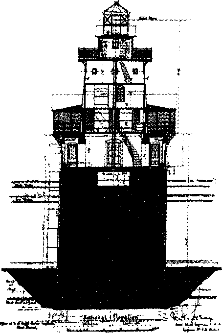
marked with lights to keep ships from running aground. Many lights, such as the Ship John Shoal
Light, though difficult to see from the mainland, are still used today. Range lights, used in pairs,
allowed ships to pinpoint their location. The Captain would sight along the two lights, one taller than
the other, and by maintaining their alignment, he could be assured that his ship was safely in the
channel.
Tributaries opening into the Delaware Bay spawned small lighthouses for the many fishing
and recreational boats. East Point Light is one of the few still standing. Its automatic light identifies
the entrance to the Maurice River.
COASTAL DEFENSE
Ships sailing the coastal waterways, carrying trade goods, troops, and provisions, sometimes entered New Jersey's
ports to load and offload their cargo. Coastal defenses were built to protect port cities,
harbors, and critically located bridges and rivers.
During the Revolutionary War, the fledgling United States supplemented its small navy with privateers. New
Jersey's secluded coves and inlets provided safe
haven for many of these privateers who were
encouraged to harass and capture enemy vessels. The secluded inlets and harbors of the
New Jersey coast were often the site of skirmishes between British and American ships. In Port
Republic, a marker commemorates the town of Chestnut Neck, burned by the British in
retaliation for the many privateers who used its harbor to dart out, surprise, and then plunder British
supply ships. Sandy Hook Light was a military target for both the American and British forces due to its strategic
location at the entrance to the British occupied New York Harbor. Enclosed masonry forts
became obsolete after the Civil War, so the United States Army built new fortifications to
defend the harbor entrance.
British and American fighting ships engaged in a number of skirmishes for control of
the Delaware River. Many coastal communities became involved in the War for Independence—Greenwich had
its own "Tea Party," and Hancock House State Historic Site at Hancocks Bridge, has
been preserved to commemorate the site of a 1778 massacre of colonial patriots.
Coastal areas were also a source of salt, a
crucial commodity widely used for preserving
food. Skirmishes for control of these productive
saltworks occurred frequently during the war.
During WWI, the town of Tuckerton became
famous when the U.S. Navy discovered an 820
foot high radio tower the Germans were building on Mystic Island. President Woodrow
Wilson seized the tower for American use. The
tall tower is gone now. but the concrete building
still remains. The strategic importance of Cape May was articulated, when the Army built a
large, concrete gun battery to guard against a possible naval invasion and constructed the Cape
May Canal to provide Navy ships safe passage from the Delaware Bay to the ocean without
having to face possible danger from enemy submarines.
The threat of war with Spain led to the 1890s construction of Fort Mott to protect the port of
Philadelphia. Its big guns could be loaded, fired, and then "disappear" behind the protection of a
camouflaged earthen and concrete wall that blended into the landscape. Enemy ships would
generally never see the weapons firing upon them.
Sandy Hook, also developed guns that could load, fire, and "disappear" behind the
protection of a camouflaged concrete wall that blended into the landscape. Nike missiles replaced the disappearing guns in
the 1950s as our nation's first line of defense. Advances in technology led to the introduction
of Intercontinental Ballistic Missiles, making coastal defense fortifications and Nike missiles
obsolete.
Finn's Point National Cemetery was designated as a burial ground for Confederate prisoners who
died in prison at Fort Delaware. Approximately 2,400 Confederate and 300 Union soldiers are
buried in the cemetery.
 Lighthouses guide ships along the busy and
often dangerous mid-Atlantic coast. Barnegat
Lighthouse marked the entrance to Barnegat Bay
and served as a reference point for trans-Atlantic
mariners. Absecon and Cape May lighthouses directed ships north to New York City and south to the
Delaware Bay for the journey to Philadelphia. Smaller lighthouses, such as the Hereford Inlet Lighthouse, warned of shoals
(where the water is shallow and difficult to navigate) and marked the openings to safe passage
and harbors.
Lighthouses guide ships along the busy and
often dangerous mid-Atlantic coast. Barnegat
Lighthouse marked the entrance to Barnegat Bay
and served as a reference point for trans-Atlantic
mariners. Absecon and Cape May lighthouses directed ships north to New York City and south to the
Delaware Bay for the journey to Philadelphia. Smaller lighthouses, such as the Hereford Inlet Lighthouse, warned of shoals
(where the water is shallow and difficult to navigate) and marked the openings to safe passage
and harbors.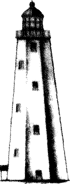 During the Revolutionary War, the fledgling United States supplemented its small navy with privateers. New
Jersey's secluded coves and inlets provided safe
haven for many of these privateers who were
encouraged to harass and capture enemy vessels. The secluded inlets and harbors of the
New Jersey coast were often the site of skirmishes between British and American ships. In Port
Republic, a marker commemorates the town of Chestnut Neck, burned by the British in
retaliation for the many privateers who used its harbor to dart out, surprise, and then plunder British
supply ships. Sandy Hook Light was a military target for both the American and British forces due to its strategic
location at the entrance to the British occupied New York Harbor. Enclosed masonry forts
became obsolete after the Civil War, so the United States Army built new fortifications to
defend the harbor entrance.
During the Revolutionary War, the fledgling United States supplemented its small navy with privateers. New
Jersey's secluded coves and inlets provided safe
haven for many of these privateers who were
encouraged to harass and capture enemy vessels. The secluded inlets and harbors of the
New Jersey coast were often the site of skirmishes between British and American ships. In Port
Republic, a marker commemorates the town of Chestnut Neck, burned by the British in
retaliation for the many privateers who used its harbor to dart out, surprise, and then plunder British
supply ships. Sandy Hook Light was a military target for both the American and British forces due to its strategic
location at the entrance to the British occupied New York Harbor. Enclosed masonry forts
became obsolete after the Civil War, so the United States Army built new fortifications to
defend the harbor entrance.
